

 Detailed Description of the current Version
 User Interface Details Prices ORTWIN
 Download
Place order
Download
Place order
 History of Modifications and Supplements


ORTWIN is a program for the country-wide inquiry of the cities and towns, localities, postal codes and dialling codes in Germany. It finds postal zip codes, dialling codes, coordinates and ground level elevations. The program determines municipal codes, local center points, car license codes, topographic maps, Unlocodes and much more. It arranges localities hierarchically into the structures Federal State, Administrative District, Rural District, town, municipality, local quarter and domicile. The program performs perimeter searches and distance calculations. It finds landscapes on different levels, natural units and climatic data like snow- and wind load zones and solar irradiations, sunshine duration and precipitation amount of all localities.
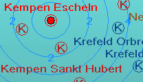
 In a radius around a localitie or around a postal code area covered localities and postal areas can be clearly represented by a comfortable perimeter search.
They can also be arranged in a list, stored as a file and printed.
In a radius around a localitie or around a postal code area covered localities and postal areas can be clearly represented by a comfortable perimeter search.
They can also be arranged in a list, stored as a file and printed.
For the local inquiries and perimeter searches a data base with more than 125.000 geocoded localities is available.
The program represents local data, determined by local inquiries and perimeter searches, in graphic overviews and data lists.
The program supports conversions between different Coordinate Systems and the distance calculation between localities.
It calculates with UTM coordinates on the reference system ETRS89 (GRS80 ellipsoid) and with geographic coordinates on the reference system WGS84.
It also uses Gauss-Krueger coordinates referenced to the Potsdam datum (DHDN, Bessel ellipsoid) and Google PlusCodes.
Towns and town quarters can be determined by entering already known data in the input fields of the data window, by clicking on overview maps or by selecting from sorted lists.
For the calculation, the values listed here can be entered directly in the input fields of the program:
For selection from separate windows are available:
In addition, the program offers the services listed here:
ORTWIN can be run on most common networks. The client installations works automatically. It is possible to use Terminal Services on WINDOWS Servers like e.g. "Citrix Terminal Server".
Because the program ORTWIN is a quite complex database application, some requirements to the hardware are to be fulfilled for its perfect working. To ensure stable performance it should be installed on a personal computer with the processor class Pentium or higher and at least 32 MB RAM available. The program will run under Microsoft WINDOWS 2000 / XP / NT / Vista / 7 / 8 / 10 / 11 and compatible operating systems.
Pricing and ordering information can be found in the Price list.
For available licensing options have a look to the License page.
Order the program with the electronic Order Form.
The free test version of the program with a detailed user manual can be downloaded as ZIP packed file by the Internet.
Managing Director Fred Killet explains why you should never use an illegal version of our geodetic program ORTWIN.
 In order that you are always well informed about our company, we write actual news, current information and special offers here into this column.
 Read more...
Read the work sheet...
Read the work sheet...
Read the work sheet...
Read the Press Release... To the NTv2 collection...
new languages can be added at any time by creating new language files.
Everybody who is interested can translate a new language file into his native language for himself and all users.
Read more...
Read the work sheet...
Read the work sheet...
Read the work sheet...
Read the Press Release... To the NTv2 collection...
new languages can be added at any time by creating new language files.
Everybody who is interested can translate a new language file into his native language for himself and all users.